
EASTERN CHUKCHI SEA
Together with the Canadian Wildlife Service, we have tracked over 200 King Eiders on their migration through the Chukchi Sea between 1997 and 2007. For more information about the tracking method, see the section on satellite telemetry.
We tracked 190 birds during their molt and fall migration, and found that 74% of the birds we caught on breeding grounds in Alaska and western Canada used the Chukchi Sea in late summer. Males migrated first and stayed about 2-3 weeks in the Chukchi Sea before continuing migration. Females made only a short stop in the area on their way south. Juveniles stayed almost 3 weeks, and migrated later than adults, with the last birds leaving the Chukchi Sea in November.
In spring we tracked 78 birds, and all King Eiders migrating to Alaska and Canada used the Chukchi Sea for 2-3 weeks during spring migration. Surprisingly, even 6 of 11 males migrating to breeding grounds in Siberia used the Eastern Chukchi Sea - despite having to fly a detour of several hundred kilometers! These birds migrated 3000 km to the west after using the Eastern Chukchi Sea. Together this indicates that the Chukchi Sea is a crucial staging area for the entire western North American population and large parts of the Siberian population.
Spring migration lasted from mid-April through mid-June, and some males were already returning to the Chukchi Sea in June before others left for breeding grounds. Hence, the Chukchi Sea is used by King Eiders continuously from mid-April through early November.
With satellite telemetry it is not possible to estimate the numbers of birds present in a given area. However, if we extrapolate our findings to the breeding population that migrates through the Chukchi Sea, we would expect all North American breeders and a large part of Siberian breeders to use this area in spring. This means that probably more than 500.000 King Eiders use the Chukchi Sea as a staging ground to accumulate body reserves for migration and the breeding season every spring.


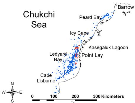
These two maps show the distribution of satellite-tagged King Eiders in the Eastern Chukchi Sea in late summer (left) and during spring migration (right). The red circles indicate high use areas calculated by fixed kernel 50% volume contours.